Photo: Tim Pierce · Public domain
Smalls Falls
If you're passing
Is it plungeworthy?
A 3-tier tiered on Sandy River.
The details
- Tiers
- 3 drops
- Type
- Tiered
- Watercourse
- Sandy River
- Coordinates
- 44.85834, -70.5162
About Smalls Falls
Smalls Falls is a tiered in Maine, on Sandy River. The water falls in 3 distinct tiers.
It's fullest after rain, and flow can drop off during dry spells — plan around recent weather.
Plungeworthy rates Smalls Falls 5.2/10 — if you're passing. The score weighs its scale, how confidently it's mapped, and its character.
What you'll find
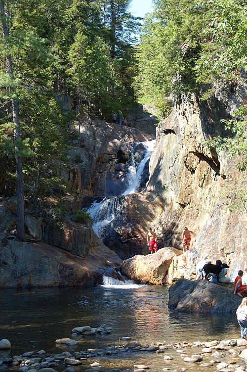
Smalls Falls is a four-tier cascade on the Sandy River just off Route 4 between Madrid and Rangeley — a rest-stop waterfall in the truest sense, visible almost from the parking lot. A footbridge crosses just below the main drop, and a short unmarked trail climbs beside the falls to a second, smaller cascade on Chandler Mill Stream above.
What makes it distinct is the combination of scale and zero effort: a 54-foot total drop broken into a slide, a segmented main fall, a horsetail, and a cascade, all inside a sculpted granite chute, reachable in under five minutes from the car. Plunge pools at the base draw swimmers on hot days, and the rock is polished smooth from generations of sliding.
It feels less like a hike and more like a scenic pull-off that happens to have real drama — the kind of stop that surprises people driving to Rangeley for the lakes and ends up being the photo they post.
Getting there
- Trailhead
- Smalls Falls Rest Area, Route 4, Township E
- Parking
- Rest area lot, free — pit toilets and picnic tables on site
- Road
- Paved, Route 4 direct
- Hike
- 0.3 mi round trip, 32 ft of climb (Easy)
- Heads up
- The trail is unmarked but obvious. The entrance sign has been reported missing in the past — use GPS to confirm the pull-off.
When to go
Best flow in spring snowmelt and after rain; the falls run thin by late summer in dry years. A roadside stop by design, it sees steady traffic all season and pairs easily with Coos Canyon or Angel Falls on a Route 4/17 loop through the Rangeley area.
Rules & fees
- Fee / pass
- None — free rest area
- Camping
- None on site
- Warnings
- Wet rock at the base is slick; swimming is popular but unofficial and at your own risk.
Researched from Wikipedia — Smalls Falls · Rangeley Lakes Heritage Trust — Smalls Falls · Maine by Foot — Smalls Falls. Conditions change — verify before you drive. Been to Smalls Falls recently? Post a conditions report below.
Where it is
Before you go
The pin marks the feature, not a trailhead or a legal route in. Some sit on private land or need a real hike, and conditions change with season and rain. Check local access, don't trespass, and never enter water — hot or cold — where it isn't safe.
Common questions
Where is Smalls Falls?
Smalls Falls is a waterfall in Maine, at 44.85834, -70.5162.
Is Smalls Falls worth visiting?
If you're passing — Plungeworthy rates it 5.2/10.
Gear for the trip
As an Amazon Associate, Plungeworthy earns from qualifying purchases.